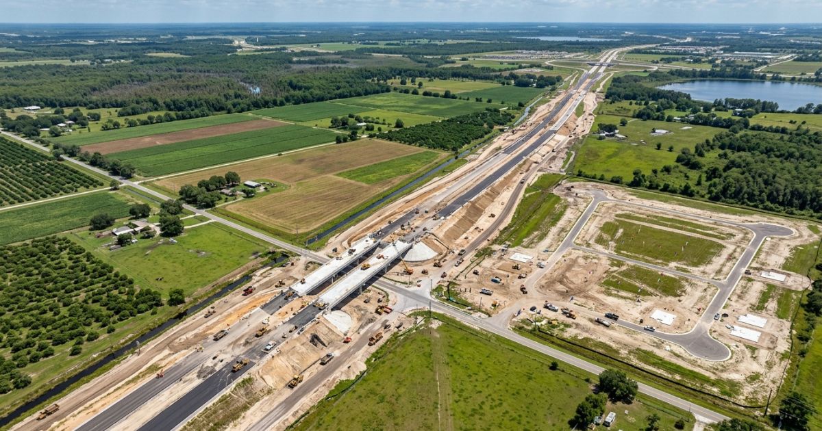
If you’re waiting for the “obvious” moment to invest in Central Florida, the visible problem is that once it’s obvious, the price has already moved. The real danger is buying too late — after the highway has opened and the subdivision next door already has a “sold out” sign. Here’s how to recognize a growth corridor before it makes headlines.
Most people think land investing comes down to picking the right city — Orlando, Tampa, Ocala. In reality, growth in Central Florida doesn’t happen city by city. It happens corridor by corridor: a band of land along a new or widened highway, where infrastructure arrives first and residential development follows close behind.
Table of Contents
- Why Central Florida is at the center of the next growth cycle
- What a growth corridor actually is
- Central Florida’s key growth corridors right now
- How to spot a corridor before prices rise
- Comparing the emerging corridors
- Common mistakes investors make in growth areas
- Hidden costs and risks of these corridors
- FAQ — Frequently Asked Questions
- 📚 Glossary
- ✅ Immediate Actions — Start Now
Why Central Florida is at the center of the next growth cycle {#why-it-matters}
Short answer: the region between Orlando and Tampa keeps adding new residents, new highways, and new jobs faster than construction can keep up — pushing residential growth outward from the urban cores and along the road corridors being expanded right now.
Orlando and Tampa are already mature metro areas, and their land prices reflect decades of buildout. The space that still offers an accessible entry price — with real upside — sits in the counties between and around those two cities: Polk, Osceola, Lake, Sumter, Volusia, and parts of Marion.
That shift isn’t random. It follows a well-documented pattern in American real estate development: road infrastructure arrives first, residential subdivisions follow within a few years, and retail and services show up last. Investors who understand that sequence can position themselves at the first stage, when land still costs a fraction of what it will once the area is built out.
What a growth corridor actually is {#what-is-a-corridor}
Short answer: a growth corridor is the band of land along a new, widened, or planned highway, where improved road access turns formerly rural or hard-to-reach parcels into viable sites for residential and commercial development.
Unlike a “hot neighborhood,” a growth corridor is defined by infrastructure, not immediate demand. It exists before most people notice, because the shift starts with technical decisions — county comprehensive plans, FDOT (Florida Department of Transportation) construction schedules, zoning approvals — long before any visible construction begins.
That means, unlike a finished home, the value of land inside a growth corridor doesn’t depend only on what exists today, but on what’s officially planned for the coming years. Evaluating that potential means reading public planning documents, not just walking the lot.
Central Florida’s key growth corridors right now {#key-corridors}
Short answer: the areas seeing the most road-expansion and residential subdivision activity in Central Florida today include the I-4 corridor between Orlando and Tampa, the Four Corners/US-27 region, the Wekiva Parkway (SR-429) area, the Poinciana–Haines City corridor, and the expansion of Sumter and Marion counties around The Villages.
The I-4 corridor (Orlando–Tampa)
Interstate 4 remains the backbone of Central Florida’s growth. The counties it runs through — Polk County in particular — have been landing major distribution centers, logistics parks, and residential subdivisions aimed at people who work in Orlando or Tampa but want a lower entry price on land.
Four Corners and the US-27 region
Where Polk, Osceola, Lake, and Orange counties meet, proximity to the theme parks combined with easier access via US-27 has turned a formerly agricultural area into one of the fastest-growing residential regions in the state, with subdivisions built for both full-time residents and short-term vacation rentals.
Wekiva Parkway (SR-429) and northwest Orlando
The completion of the beltway connecting Apopka, Sorrento, and Mount Dora opened direct access to parts of Lake County that previously required longer drives into Orlando. Land along this route, especially near the newer interchanges, has drawn interest from both homebuyers and small investors.
Poinciana and Haines City (southern Osceola and Polk)
The expansion of Poinciana Parkway and continued investment along US-17/92 are connecting Poinciana and Haines City more directly to Kissimmee and Orlando, easing the isolation that historically kept land prices lower in this part of the region.
Sumter and Marion — expansion around The Villages
The continued growth of The Villages keeps pushing residential development beyond the community’s traditional boundaries, toward Wildwood, Bushnell, and southern Marion County — areas that still hold large tracts of rural land with potential for residential conversion.
How to spot a corridor before prices rise {#how-to-spot}
Short answer: the most reliable signals of a growth corridor forming are road-expansion projects already approved and funded by FDOT, recent changes to a county's comprehensive plan that authorize residential use, and large homebuilders acquiring land within a few miles of the area.
None of these signals alone guarantees appreciation — but two or three together usually mean a region is entering the early phase of a growth cycle:
- FDOT Five-Year Work Program — a public schedule listing highway projects with approved, funded construction over the next five years
- Changes to the county’s Future Land Use Map — reclassifying rural land for residential or mixed use often precedes actual development by several years
- National homebuilders moving in — when large builders start buying land in a region, it’s usually because they’ve already run their own growth and infrastructure analysis
- Rising building permit volume — the number of permits a county issues is a more reliable measure of real growth than market buzz or forward-looking announcements
Comparing the emerging corridors {#comparison-table}
| Corridor | Main growth driver | Current stage | Typical investor profile |
|---|---|---|---|
| I-4 (Orlando–Tampa / Polk) | Logistics, distribution, and commuters between the two metros | Advanced growth, still expanding | Mid-term investor, focused on commercial and residential land |
| Four Corners / US-27 | Proximity to theme parks and short-term rental demand | Accelerated growth | Short-term rental investor |
| Wekiva Parkway / SR-429 | New road access to northwest Orlando | Early to moderate growth | Homebuyer and raw land investor |
| Poinciana–Haines City | Improved road access and lower entry price | Early growth | Long-term investor with higher risk tolerance |
| Sumter/Marion (around The Villages) | Ongoing expansion of a large planned retirement community | Early to moderate growth | Raw land investor, land banking |
Common mistakes investors make in growth areas {#common-mistakes}
Buying on the promise of a highway, not an approved project
There’s a big difference between a “planned” highway mentioned in a preliminary study and one with funding approved and a schedule listed in FDOT’s Five-Year Work Program. Land sold on the strength of the first often waits years — sometimes decades — for the promised appreciation to show up.
Ignoring the parcel’s current zoning
A lot can sit inside an obvious growth corridor and still carry agricultural zoning with no near-term plan for a residential change. Checking the current zoning — not just future potential — keeps an investor from buying an asset that can’t be used the way they imagined.
Confusing population growth with guaranteed appreciation
Population growth is one of the factors that supports long-term appreciation, but it’s not an automatic guarantee. An oversupply of platted lots in a single area, for example, can keep prices flat longer than expected.
Skipping utility access before buying
Being close to a new road corridor doesn’t mean water, sewer, and power are already available. In many emerging areas, utility infrastructure arrives after the highway does, which directly affects the cost and timeline for making a lot buildable.
Hidden costs and risks of these corridors {#hidden-costs}
- Higher impact fees — fast-growing counties frequently raise the fees charged to new developments to fund their own infrastructure, which can push up the final cost of building
- Concurrency and road capacity — some counties require roads, schools, and drainage to have enough capacity before approving new subdivisions, which can delay projects even in areas already zoned for growth
- Premature speculation — in heavily publicized corridors, land prices can climb before infrastructure is even finished, shrinking the upside for anyone who buys late in that same cycle
- Comprehensive plan changes — land-use reclassifications can be reversed or delayed by local political decisions, especially in counties facing strong resident pushback against growth
- Cost of utility extension — running water and sewer out to a lot farther from the built-out corridor can cost tens of thousands of dollars, depending on the distance to the existing network
FAQ — Frequently Asked Questions {#faq}
What exactly is a growth corridor?
It’s the band of land along a new, widened, or improved highway, where easier road access tends to attract residential and commercial subdivisions in the years following construction.
Is it safe to buy land in an area that’s still developing?
It can be, as long as the investor verifies public records — like the county’s comprehensive plan and FDOT’s construction schedule — instead of relying only on appreciation projections from agents or developers.
How do I know if a planned highway will actually get built?
The most reliable indicator is whether the project appears in FDOT’s Five-Year Work Program, which only lists projects with approved funding. Projects mentioned solely in preliminary studies aren’t guaranteed to move forward.
Is it always worth buying early in a growth corridor?
Not necessarily. Buying too early, before any infrastructure is approved, raises the risk that the land sits for years without appreciating. The ideal window is usually after a project is approved and funded, but before residential development has fully built out.
Does the land need to already have residential zoning approved?
No, but it’s essential to understand the current zoning and the process required for a future change — including timelines and costs — before basing a purchase decision solely on the area’s future potential.
📚 Glossary {#glossary}
Growth Corridor: the band of land along a new or expanded highway where real estate development tends to concentrate in the following years.
FDOT Five-Year Work Program: a public schedule of Florida highway projects with approved, funded construction over the next five years.
Future Land Use Map: an official county map defining the permitted use for each area — residential, commercial, agricultural, and so on — that guides zoning decisions.
Comprehensive Plan: a document that guides a county’s or city’s long-term growth, including land use, infrastructure, and public services.
Impact Fees: charges levied on new developments to fund the additional public infrastructure that growth requires, such as roads, schools, and water systems.
Concurrency: a requirement that public infrastructure (roads, schools, drainage) have adequate capacity before a new development can be approved.
Land Banking: the strategy of buying and holding raw land for a period, betting on appreciation driven by a region’s future growth.
Master-Planned Community: a residential community designed as an integrated whole, typically including retail, schools, and its own infrastructure from the start of the project.
✅ Immediate Actions — Start Now {#immediate-actions}
- Check FDOT’s Five-Year Work Program to confirm approved, funded road projects in the area you’re considering
- Review the county’s Future Land Use Map and current zoning before evaluating a parcel’s potential
- Research whether large homebuilders are already acquiring land near the area you’re evaluating
- Ask the county directly about the availability and estimated cost of extending water and sewer to the property
- Review the region’s recent building permit history
- Talk to TerraNoble for bilingual guidance on Central Florida’s growth corridors and available land
Conclusion
Central Florida’s growth corridors aren’t a secret — information about new highways, comprehensive plans, and approved subdivisions is public. The difference between investing early and safely versus buying late, at an already-consolidated price, comes down to knowing where to look for that information before making a decision.
No corridor guarantees automatic appreciation, and any promise otherwise deserves skepticism. What these corridors offer is a real window, grounded in publicly planned infrastructure, for investors willing to do the verification work before they buy.
TerraNoble offers bilingual support — in English and Portuguese — to help investors understand the real potential of each Central Florida region, based on public data rather than market hype. Get in touch with our team to review the options available across the state’s leading growth corridors.